
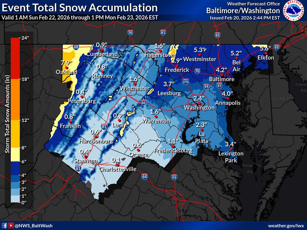
The National Weather Service issued a winter storm watch for several areas in Maryland, anticipating a coastal system that could bring up to 5 inches of snow to certain regions.
This watch will be in effect from Sunday afternoon until Monday morning, affecting Baltimore, Montgomery, Howard, Harford, Frederick, and Carroll counties.
The National Weather Service noted, “Snow may start on Sunday morning, but the heaviest snowfall and the coldest temperatures are expected late Sunday afternoon through early Monday morning.”
According to the latest AccuWeather forecast, the storm is projected to move from the Gulf Coast on Saturday to the Atlantic coast on Sunday, potentially spreading snow across West Virginia, Virginia, Pennsylvania, and into the mid-Atlantic and New England regions.
While the exact path and intensity of the storm are still uncertain, the majority of the Baltimore area is likely to experience a combination of light rain and snow starting overnight on Saturday and continuing into Monday.
Dan DePodwin, AccuWeather vice president of forecasting operations, stated, “The critical factor for determining heavy versus light snow along I-95 is the storm’s coastal track, which will influence how quickly it intensifies.”
The Capital Weather Gang from The Washington Post suggests that residents in the Baltimore area should prepare for light rain and mixed precipitation during the early hours of Sunday, followed by a mix of rain and snow throughout the day.
They noted, “We expect any snowfall to be relatively light, with temperatures in the mid-30s or higher, which may limit accumulation during daylight hours. However, we cannot dismiss the possibility of snow becoming heavy enough to lower temperatures closer to freezing, leading to some accumulation, particularly on grassy surfaces, by late afternoon.”
Snow is anticipated on Sunday night, presenting the best opportunity for accumulation. Forecasters also indicate a chance of lingering snow through Monday morning.
As the workweek begins, Marylanders should brace for chilly temperatures slightly above freezing, with milder conditions expected by midweek.
Here’s a detailed look at the National Weather Service forecast for the Baltimore area:
Friday Night: Partly cloudy, with a low around 37°F. Winds from the west at 6 to 10 mph, gusting up to 18 mph.
Saturday: Mostly cloudy, gradually becoming sunny, with a high near 51°F. Northwest winds at 3 to 6 mph.
Saturday Night: Chance of rain after 1 AM, mixing with snow after 4 AM. Increasing clouds, with a low around 33°F. Calm winds. Chance of precipitation is 50%.
Sunday: Rain and snow expected. High near 39°F. Calm winds shifting to northeast at 5 to 7 mph in the afternoon. Chance of precipitation is 90%. Minimal snow accumulation anticipated.
Sunday Night: Snow, possibly mixed with rain, transitioning to all snow after 10 PM. Low around 30°F. North winds at 6 to 8 mph. Chance of precipitation is 90%. New snow accumulation of 2 to 4 inches possible.
Monday: A chance of snow before 1 PM, followed by a chance of rain and snow. Mostly cloudy, with a high near 38°F. Chance of precipitation is 50%.
Monday Night: Mostly cloudy, with a low around 25°F.
Tuesday: Mostly sunny, with a high near 35°F.


