
Residents of Maryland are being urged to prepare for another wave of dangerously cold weather this weekend, accompanied by strong winds and the possibility of additional snowfall.
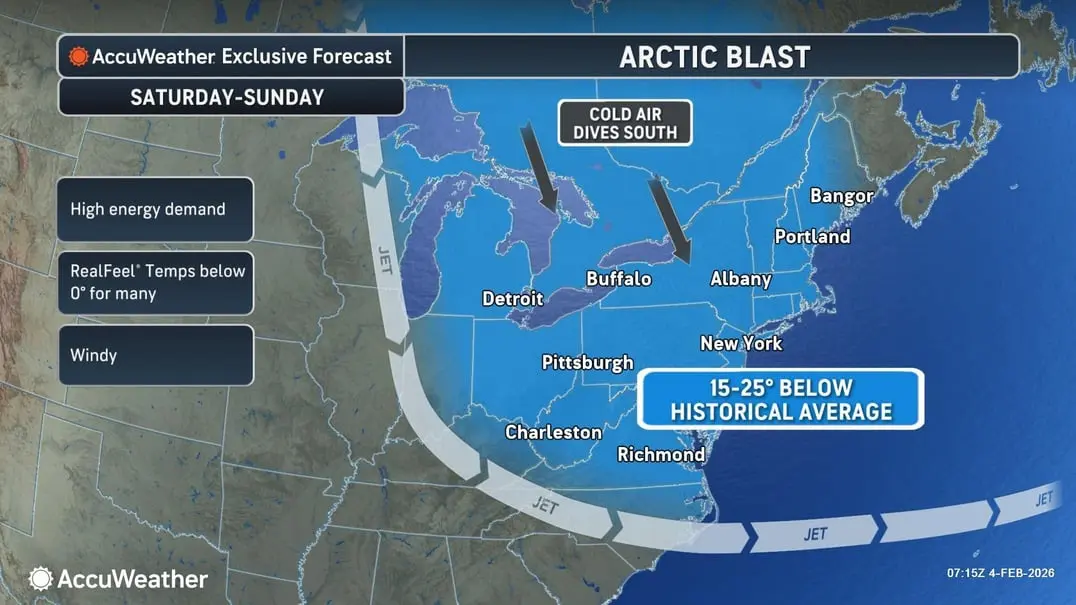
According to the latest updates from AccuWeather, an Arctic front is set to move from the Great Lakes into the Northeast and mid-Atlantic regions from Friday to Saturday. This front may bring snow squalls, damaging wind gusts, and a return to frigid temperatures along with severe wind chills.
The highest likelihood of snow accumulation will be in the far western parts of Maryland, where a winter storm watch is in effect from Friday to Saturday. However, the Baltimore area may also experience some snowfall, particularly along and north of Interstate 66/Route 50.
In a forecast discussion released on Wednesday, the National Weather Service indicated that areas of Maryland east of the Alleghenies and along the Interstate 95 corridor could experience wind gusts exceeding 40 to 45 mph on Friday and Saturday as the front passes through the state.
In addition to the wind, temperatures across the state are forecasted to drop significantly, creating serious safety concerns for Marylanders who are still working to clear roads, driveways, and sidewalks of ice from the previous winter storm.
Low temperatures are projected to fall into the single digits and teens on Friday night, with Saturday’s highs struggling to reach the mid-20s. Saturday night will also see lows dipping into the single digits, with widespread subzero wind chills expected late Saturday into early Sunday.
Forecasters warn that the gusty winds will not only heighten the risk of dangerous wind chills but may also lead to isolated tree damage and power outages.
According to meteorologists, the anticipated wind chills pose a “life-threatening” risk for hypothermia and frostbite to exposed skin.
“If you must travel, have a cold-weather survival kit. Limit your time outdoors and cover any exposed skin,” the National Weather Service advised. “Make sure pets and livestock are adequately sheltered from the cold, take precautions to prevent frozen pipes, and avoid traveling on frozen bodies of water where ice thickness is uncertain.”
If you need to go outside during these cold conditions, it’s crucial to wear multiple layers of loose-fitting, lightweight clothing instead of a single heavy layer. The outer layer should be tightly woven and water-resistant. Opt for mittens, which provide more warmth than gloves, and wear a hat and face covering to minimize heat loss.
Additionally, stay dry. If your clothing gets wet, change into a dry set immediately. Wet clothing loses its insulating properties and can draw heat away from your body more quickly.
Here’s a detailed forecast for the Baltimore area:
Wednesday Night: Mostly cloudy, with a low near 14°F. North wind around 5 mph.
Thursday: Sunny, with a high near 31°F. North wind 5 to 9 mph.
Thursday Night: Partly cloudy, with a low around 13°F. Light northwest wind.
Friday: A chance of snow after 1 PM. Partly sunny, with a high near 34°F. Calm wind shifting to southwest around 5 mph. Precipitation chance is 30%.
Friday Night: A chance of snow, mainly before 1 AM. Mostly cloudy, with a low around 14°F. Precipitation chance is 50%.
Saturday: Sunny, with a high near 24°F. Blustery conditions expected.
Saturday Night: Mostly clear, with a low around 8°F.
Sunday: Mostly sunny, with a high near 22°F.
Sunday Night: Partly cloudy, with a low around 14°F.
Monday: Partly sunny, with a high near 32°F.


