
A rapidly approaching winter storm is expected to deliver up to an inch of snow to the Baltimore area starting Tuesday night, potentially leading to icy road conditions and hazardous travel for commuters.
Meteorologists are closely monitoring the storm as it progresses eastward into colder air, moving toward the mid-Atlantic coastline, according to the latest AccuWeather update. A significant blanket of snow is anticipated across Maryland, Virginia, and Delaware.
Although snowfall amounts are predicted to be less than those from recent storms, cities such as Baltimore and Washington, D.C. might receive up to an inch late Tuesday night into Wednesday morning, according to AccuWeather forecasts.
Concerns about travel disruptions and refreezing roads have led the National Weather Service (NWS) to issue a winter commuting hazard for Wednesday morning.
NWS meteorologists have also indicated a similar timeline for potential snowfall in a hazardous weather outlook released on Tuesday.
“Light snow accumulation is possible this evening through early Wednesday morning. Should this occur, travel disruptions may follow,” the National Weather Service stated.
Forecasters warned that any snowfall could pose risks for commuters on Wednesday morning.
“If you plan to commute Wednesday morning, be prepared for potential significant travel delays,” NWS meteorologists advised. “It’s wise to allow for extra travel time and consider public transportation or telecommuting options.”
Looking ahead, an Arctic front may bring snow showers and strong winds to the Baltimore area on Friday. Following this front, dangerously low wind chills are expected overnight and into the morning from Friday night through Monday morning, according to the National Weather Service.
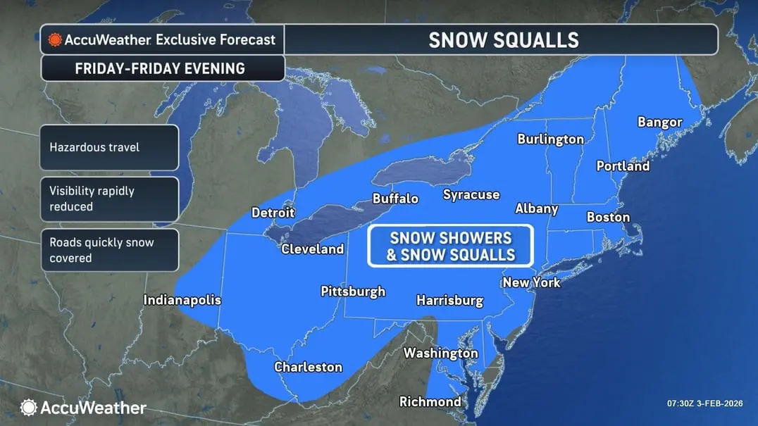
Forecasters noted that snow showers and squalls could develop along and ahead of the front, impacting both the Friday morning and evening commutes.
“The Arctic front may also bring damaging winds and power outages late Friday night into Saturday, along with gale to storm-force winds over the waters and freezing spray over ice-free areas,” the National Weather Service added.
Here’s the latest weather forecast for the Baltimore region:
Tuesday Night: Likely snow showers, mainly between midnight and 4 AM. Patchy fog after 11 PM. Otherwise, cloudy with a low around 23°F. Calm winds shifting to the north around 6 mph after midnight. Chance of precipitation is 60%. New snow accumulation of less than half an inch is possible.
Wednesday: Partly sunny with a high near 32°F. North winds around 9 mph.
Wednesday Night: Mostly cloudy with a low around 15°F. North winds at 3 to 7 mph.
Thursday: Sunny with a high near 30°F. Northwest winds at 6 to 9 mph.
Thursday Night: Partly cloudy with a low around 15°F.
Friday: A chance of snow. Mostly cloudy with a high near 34°F. Chance of precipitation is 40%.
Friday Night: Partly cloudy with a low around 17°F.
Saturday: Sunny with a high near 25°F. Blustery conditions expected.
Saturday Night: Mostly clear with a low around 11°F.
Sunday: Mostly sunny with a high near 25°F.


