
Weather experts are closely watching a winter storm that may impact Maryland, bringing snow and strong winds to the Baltimore area this weekend. Additionally, there is a possibility of snow on Wednesday, which could disrupt the afternoon commute, based on the latest weather updates.
A storm is anticipated to intensify along a stalled front near the Gulf Coast late this week. Precipitation could begin as early as Friday in parts of the Southeast before moving eastward and northward into the weekend, according to AccuWeather.
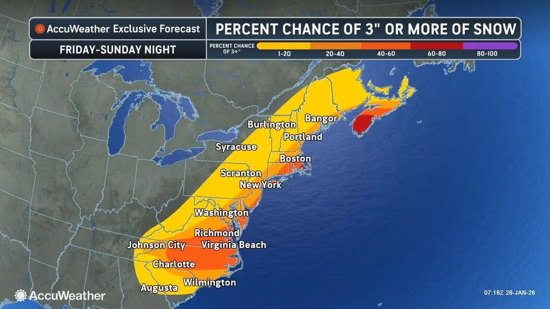
In a different forecast, the National Weather Service’s Weather Prediction Center indicated growing confidence in significant snowfall for the Carolinas and southern Virginia. Meanwhile, the likelihood of substantial snowfall remains lower in Maryland and further north along the East Coast.
AccuWeather predicts that the Baltimore area has a 20 to 40 percent chance of receiving 3 or more inches of snow, with less than a 20 percent chance of accumulating 6 inches or more.
This storm system is also expected to generate strong winds, which, when combined with the snow, may lead to reduced visibility and hazardous travel conditions. Along the Maryland coastline, high winds coupled with elevated tides could result in coastal flooding and dangerous surf conditions.
“Several factors regarding this potential winter storm remain uncertain, and we anticipate forecast adjustments as the system approaches,” stated the Weather Prediction Center.
In addition, frigid temperatures are expected to persist well into the following week, with wind chill values occasionally dropping below zero. A cold weather advisory will take effect on Wednesday at 7 p.m. and will remain in place until 11 a.m. on Thursday.
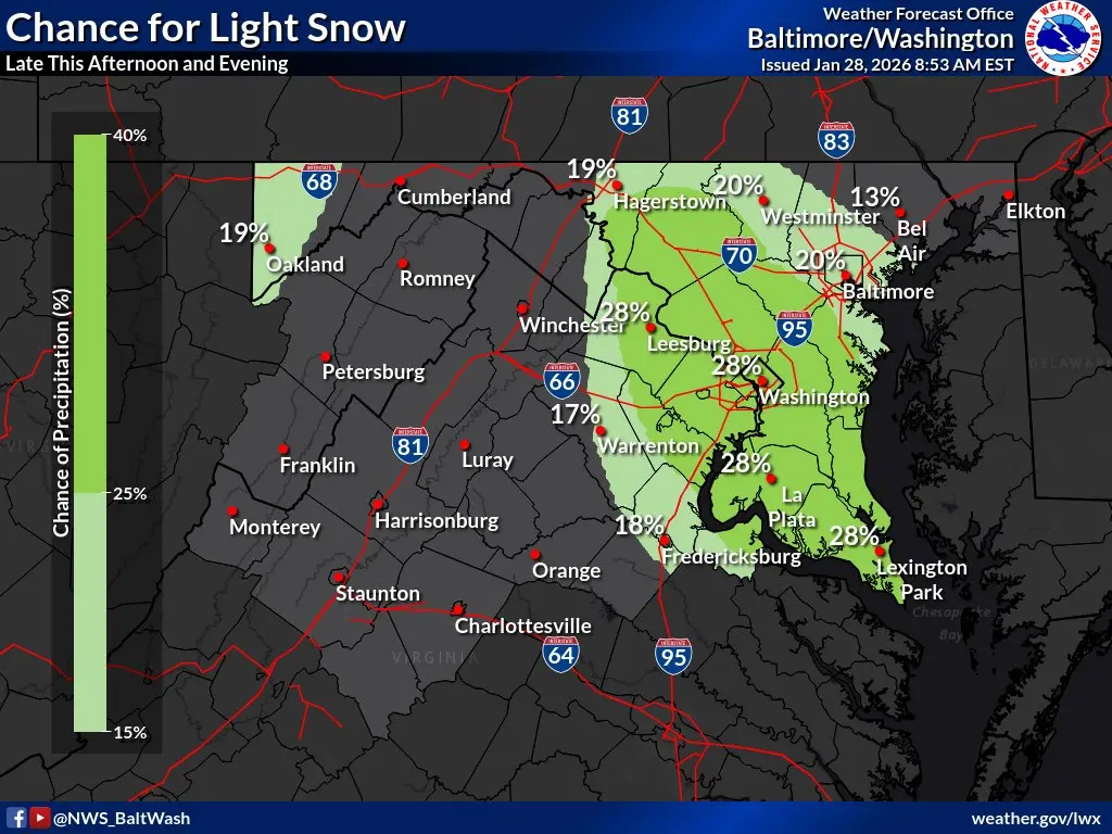
Forecasters also mentioned a 20 to 30 percent chance of light snow moving through the Baltimore area from northwest to southeast later on Wednesday afternoon into the evening.
“If snow occurs, a light dusting of around half an inch could be possible during the evening commute,” forecasters noted.
Here’s the latest National Weather Service forecast for the area:
Wednesday: Slight chance of snow after 2 p.m. Mostly cloudy, with a high near 21. West winds at 6 to 8 mph. Chance of precipitation is 20%.
Wednesday Night: Slight chance of snow before 10 p.m. Mostly cloudy, gradually becoming clear, with a low around 8. Wind chill values could drop to -2. Calm winds shifting to west at around 6 mph after midnight. Chance of precipitation is 20%.
Thursday: Sunny, with a high near 22. Wind chill values may reach as low as -1. West winds at 6 to 10 mph, gusting up to 18 mph.
Thursday Night: Mostly clear, with a low around 8. Northwest winds at 3 to 6 mph.
Friday: Mostly sunny, with a high near 20. Northwest winds at 3 to 7 mph.
Friday Night: Partly cloudy, with a low around 8.
Saturday: Partly sunny, with a high near 18.
Saturday Night: Chance of snow after 1 a.m. Mostly cloudy, with a low around 13. Chance of precipitation is 30%.
Sunday: Chance of snow before 1 p.m. Partly sunny, with a high near 26. Chance of precipitation is 30%.
Sunday Night: Partly cloudy, with a low around 17.
Monday: Mostly sunny, with a high near 32.


