
This week, Maryland might experience two additional rounds of snow, as the cold weather continues to complicate efforts to clear roads and driveways from the late January snowstorm.
The first snowfall is anticipated from Tuesday night into Wednesday, according to the National Weather Service. Accumulations are expected to be minimal, with a coating of less than an inch.
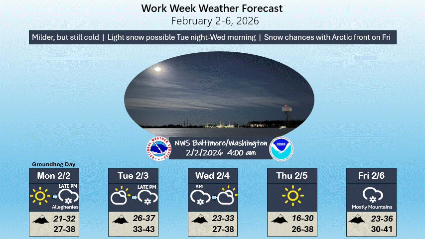
“A brief warm spell is expected until Tuesday. A clipper system will likely bring light snow Tuesday night,” the NWS stated. “Temperatures will drop again in the middle and later part of the week. An Arctic front is set to move through on Friday night, bringing snow showers and significantly colder temperatures for the weekend.”
The next opportunity for snow arrives on Friday as a robust clipper system approaches ahead of the Arctic front, as noted by National Weather Service forecasters.
While parts of southern Maryland and Northern Virginia may see temperatures rise above freezing on Monday, this respite will be short-lived, according to meteorologists.
“Today will be sunny and warmer, with many areas seeing temperatures rise above freezing for the first time in over a week,” the agency reported.
“Cloud cover will increase on Friday, with temperatures not as cold. Highs are expected to reach the mid-30s, and light snow showers or flurries may be possible,” the Post reported. “We will return to frigid conditions over the weekend, with highs only in the 20s and lows dropping to single digits or around 10 degrees. However, milder weather is expected to return next week.”
Residents throughout the DMV area have struggled to clear their driveways and sidewalks, with many residential streets, school driveways, and bus stops still covered in ice. This situation has resulted in another week of canceled classes or delayed starts.
Anne Arundel County Public Schools and Howard County Public Schools both opened two hours late on Monday and plan to do the same on Tuesday.
Montgomery County Public Schools and Prince George’s County Public Schools were closed on Monday.
Here’s the latest weather forecast for Maryland from the National Weather Service:
Monday Afternoon
Sunny, with a high near 32. Winds from the west at 6 to 11 mph, with gusts up to 18 mph.
Monday Night
Partly cloudy, with a low around 19. Calm winds.
Tuesday
A slight chance of rain and snow after 4 PM. Increasing clouds, with a high near 39. Calm winds shifting to the southwest at around 5 mph. Chance of precipitation is 20%.
Tuesday Night
Snow is likely, mainly before 1 AM. Cloudy, with a low around 26. Calm winds. Chance of precipitation is 60%. New snow accumulation of less than one inch is possible.
Wednesday
Mostly sunny, with a high near 32. North winds at 5 to 7 mph.
Wednesday Night
Partly cloudy, with a low around 17.
Thursday
Sunny, with a high near 28.
Thursday Night
Partly cloudy, with a low around 16.
Friday
Chance of snow. Mostly cloudy, with a high near 33. Chance of precipitation is 50%.
Friday Night
Partly cloudy, with a low around 15.
Saturday
Sunny, with a high near 21. Blustery conditions expected.
Saturday Night
Mostly clear, with a low around 11.
Sunday
Mostly sunny, with a high near 24.


