
This weekend, Maryland is bracing for an Arctic front that will usher in extremely low temperatures, strong winds, and snow across the Baltimore area.
A surge of frigid air is expected to move southward from Friday into Saturday, impacting over 100 million individuals across several states, including Maryland. Meteorologists predict that the most severe weather conditions will occur during the early part of the weekend, with snow and high winds accompanying the cold front.
According to The Washington Post’s Capital Weather Gang, Friday will begin with sunshine but will transition to cloudy skies by the afternoon.
“Snow showers are expected to arrive in western areas first, likely reaching the Beltway around late afternoon or sunset,” noted the Capital Weather Gang. “High temperatures in the low to mid-30s may limit snow accumulation to just a dusting.”
The most significant snowfall is anticipated between 1 p.m. and 7 p.m., potentially affecting the Friday evening commute.
“If the snow materializes, untreated roads could quickly become covered in snow and slippery, leading to dangerous travel conditions,” forecasters warned. “If you plan to commute this afternoon and evening, be prepared for possible significant travel disruptions.”
Snow showers will be sporadic into the evening as the Arctic front approaches. Forecasters predict up to half an inch of snow for the Baltimore area.
As the front moves out of the state, temperatures are expected to drop into the teens, and strengthening winds may lead to snow squalls.
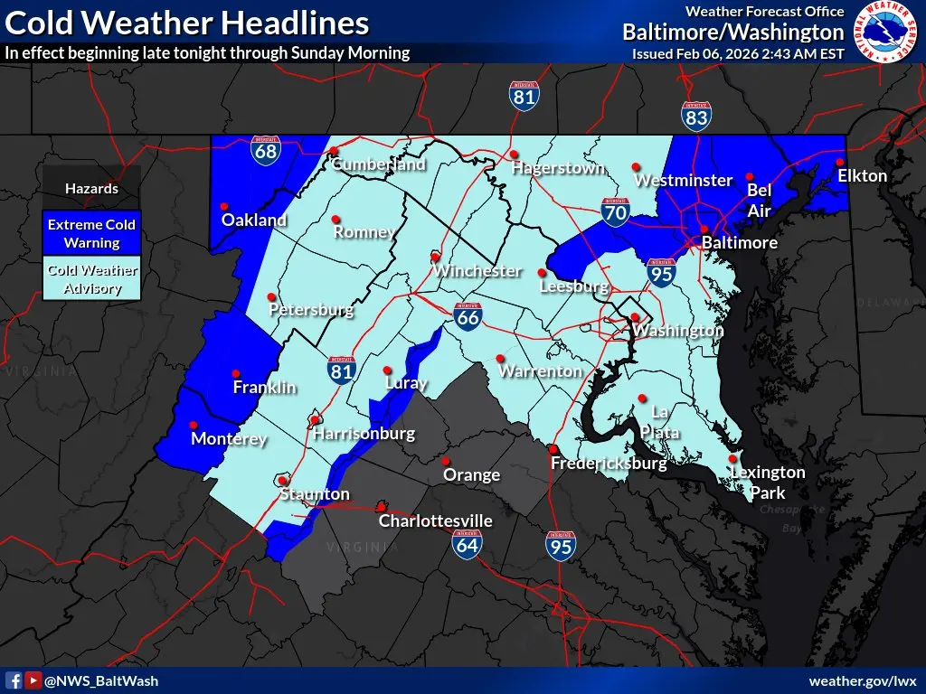
Due to these forecasts, multiple advisories and warnings have been issued for Maryland this weekend, according to the National Weather Service.
A high wind warning is in effect from 4 a.m. to 7 p.m. Saturday, covering Baltimore, Anne Arundel, Montgomery, Howard, Harford, and Prince George’s counties. The warning indicates northwest winds of 20 to 30 mph, with gusts potentially reaching 60 mph.
“These damaging winds could knock down trees and power lines,” the National Weather Service stated. “Widespread power outages are likely, and travel will be challenging, especially for high-profile vehicles.”
An extreme cold warning will also be in effect for the entire Baltimore region from 4 a.m. Saturday through 10 a.m. Sunday, while other counties in Maryland will be under a cold weather advisory.
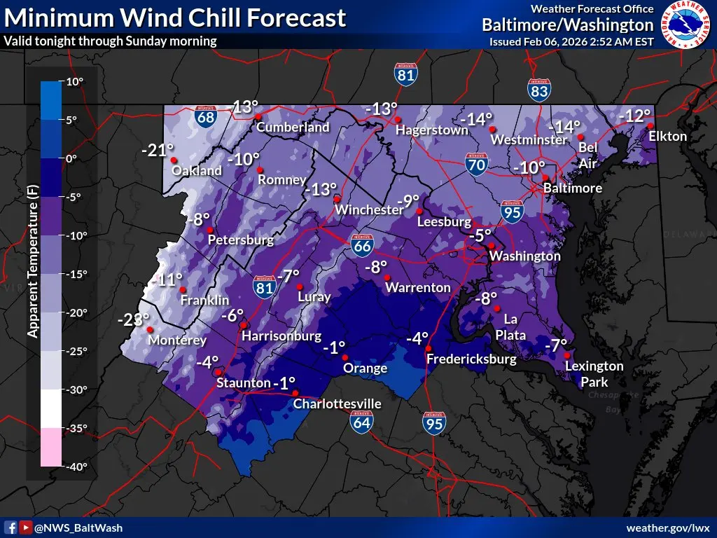
Wind chills are expected to drop to dangerously low levels, ranging from 10 to 15 degrees below zero. These wind chills will remain at or below zero throughout Saturday due to the combination of strong winds and low temperatures.
“(The wind chills) could lead to hypothermia if proper precautions are not taken,” warned National Weather Service forecasters. “Frostbite and hypothermia may occur if exposed skin is not protected from these temperatures.”
Sub-freezing temperatures are expected to persist into early next week.
“The duration of these freezing temperatures will continue to heighten the risk of impacts on both people and infrastructure,” according to the National Weather Service.
Here’s the latest detailed forecast for the Baltimore area:
Friday: Expect a chance of snow, mainly after 4 p.m. The day will be mostly cloudy, with a high around 32 degrees. Light southwest winds are expected. The chance of precipitation is 40%.
Friday Night: A chance of snow is possible between midnight and 1 a.m. The night will be cloudy, gradually becoming partly cloudy, with a low around 10 degrees. Light and variable winds will shift to northwest at 12 to 17 mph after midnight, with gusts possibly reaching 33 mph. The chance of precipitation remains at 40%.
Saturday: Expect sunny skies with a high near 17 degrees. Wind chill values could dip as low as -9. A northwest wind will blow at 21 to 28 mph, with gusts as high as 60 mph.
Saturday Night: Mostly clear skies are expected, with a low around 7 degrees. Wind chill values may fall to -9. Blustery conditions will persist with northwest winds at 13 to 20 mph, gusting up to 38 mph.
Sunday: Mostly sunny with a high near 23 degrees. Northwest winds will be 10 to 14 mph, with gusts reaching 26 mph.
Sunday Night: Expect mostly clear skies with a low around 9 degrees.
Monday: Partly sunny, with a high near 29 degrees.
Monday Night: Mostly cloudy with a low around 19 degrees.
Tuesday: Partly sunny with a high near 41 degrees.


